- Total trail distance hiked: 2,048.3 miles | 3,296.4 km
- Days on trail: 113
Current stop: Bend, Oregon
Prior to starting trail I hadn’t really heard too much about the Oregon section of the PCT other than it was relatively flat, there were crazy mosquitoes, and people generally hiked it pretty quickly.
With this is mind (and having relatively few expectations), I have been incredibly impressed with Oregon and the section since Ashland has been rivalling the Sierra in terms of picturesqueness!
 |
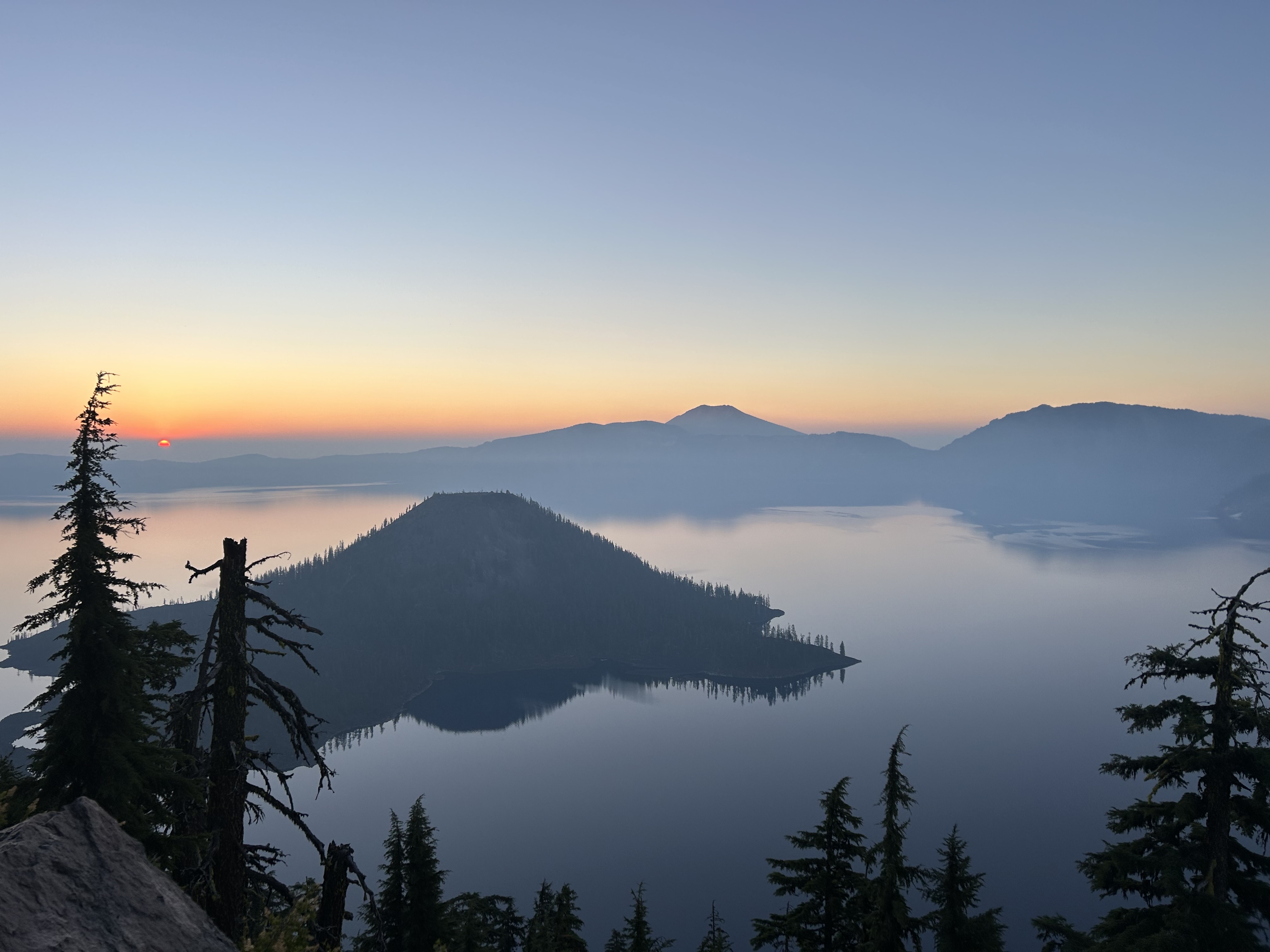
One of my favourite pictures from trail to date.
Banana Bread, PowerPuff, and Sprouts at Crater Lake |
After town chores (and consuming too many calories), we set off to leave Ashland in the late afternoon of Day 100. While our hitch back to trail wasn’t as easy as the one the day prior (I’m not sure there will ever be one as easy!), we had scored one within about 15 minutes.
A few notes on the topic of hitching:
1) Your chances of getting a hitch increases exponentially if you are hiking with girls in your group. On trail this phenomenon is called having a ‘ride bride’. I was encouraged to hide behind a tree while we waited for a hitch (should I be offended?).
2) You quickly learn the types of cars that will pick you up. Luxury European cars? Absolutely no chance. Pick up trucks, Subarus, and cars with outdoor activity equipment strapped on? You betcha.
It was no surprise that our lift back to trail then was in a 2010 Subaru Outback with a kayak strapped onto its roof.
Once back on trail we only hiked about two miles to camp and settled in for the night.
When we woke on Day 101 we were surprised that a thick layer of smoke was hanging in the air (the previous day there had been none). Our plan for the day was to hike 30 miles to Klum Campground (a car-accessible campsite) that had showers and flushing toilets - a true luxury on trail.
 |
A little smoky (little did we know what was coming up)
|
After a sleep in on Day 102, we set off from camp just after 7am. The terrain in Oregon thus far had been considerably more gentle than previous sections so knowing that we only had 27 miles to hike meant a slightly later start was justified.
After 13 miles we arrived at our water source (an old fashioned manual pump) and took a break while we filtered water and collected huckleberries. The number of berries in this section has had a serious impact on my hiking speed and I’m stopping every few metres for another snack. Just before camp that night, we received trail magic in the form of Gatorade and Oreos (a great pre-dinner aperitif and amuse-bouche).
 |
| Pumping and then filtering water |
 |
| Freshly picked huckleberries |
 |
| Views of Mt McLoughlin |
The following morning I awoke to an unfamiliar sound not yet heard on trail: the gentle tapping of drizzle on my tent. After 102 days of hiking, we were rained on for the first time (imagine 102 consecutive days with no rain in Wellington…). The drizzle was sporadic over the day and brought down the temperature considerably, making for very pleasant hiking conditions. Just when we arrived at camp, the sun started to come out which gave the tent a chance to dry before turning in for the night.
 |
| Despite the heat (albeit rain this day) snow still makes an appearance from time to time |
Day 104 was one of my highlights from the whole trail so far. I had been looking forward to seeing Crater Lake for a long time. After several miles of burn zones, we crossed the threshold into Crater Lake National Park (our fifth National Park on trail).
 |
| 🍄 |
Crater Lake was simply incredible! It is the deepest lake in the US and the water is a brilliant shade of blue. Many hours were spent at the rim of the crater taking photos.
After waking up early enough to catch the sunrise at the rim, we set off to continue hiking on Day 105.
 |
| Sunrise at Crater Lake |
Just after the north entrance of Crater Lake National Park, another fire had broken out and had closed ~50 miles of the PCT. There were two options: 1) skip up to Shelter Cove by hitchhiking to where the PCT was open again; or 2) walk along the highway and a series of forest service roads about 70 miles to Shelter Cove.
Sprouts and PowerPuff elected to hitchhike, I decided to try the road walk to not break my footpath in Oregon. After agreeing to meet at Ollalie Lake (in about 150 miles on 11 August), I said goodbye (temporarily) and set off on the roads alone.
Simply put, the road walk was unpleasant. There was a lot of smoke in the air and hiking along the (barely existent) shoulder of the highway was not fun. Given the dearth of scenery, I entertained myself by timing on my watch (how old fashioned!) how long it took to walk each mile marker on the highway and tried to beat each mile - the pinnacle of entertainment, I know.
 |
| Highlights from the road walk |
 |
| I hiked along forest service roads to avoid the highway where possible |
 |
At least the smoke made it seem somewhat atmospheric
|
At about 7pm on Day 106, I arrived at Shelter Cove. I was happy to be welcomed by Sid (who I hadn’t seen in about 400 miles) with a beer in hand. Despite my eyes and throat being a bit affected by all the smoke the previous days, sleep came easy that night.
 |
| Always good to see a familiar face: Sid. |
Sid and I left Shelter Cove at around 11am the following day (Day 107) and a much needed cooked breakfast, shower, and laundry.
The scenery leaving Shelter Cove was beautiful. If I wasn’t so pressed for time, I would have jumped in all of the lakes we passed.
 |
| Rosary Lakes |
 |
| Not bad |
At about 5pm, Sid called it a day. Knowing that I had lots of miles to do if I was going to have any hope of catching up with Sprouts and PowerPuff, I decided that I had to keep going for the day. I hiked for another 15 or so miles until sunset.
 |
| Both of these photos were taken on Day 107. It’s so crazy how the burn zones can be so close to the lush and verdant forests. |
When I woke up on Day 108, the mesh of my tent was covered in mosquitoes - I stopped counting when I reached 75 mosquitoes (perhaps my decision to camp so close to a lake was ill thought out?). Donning my full rain gear, I disassembled my tent in record time and hit the trail again determined to not stop until the mosquitoes were gone. Luckily, after about three miles the mozzies disappeared (phew!).
The next two days I would have to average about 42 miles per day if I was going to reach the others in time. This would have been fine if the views weren’t so stunning and I wasn’t stopping every few minutes for photos.
Day 108 was spent in the Three Sisters Wilderness hiking alongside the titular three volcanoes. Day 108 was what I consider to be a perfect day on trail and one of my favourites for sure.
 |
| First view of South Sister |
 |
| Approach to South Sister |
 |
| Obsidian (excuse the weird hand angle - this made my hand look the most clean) |
 |
| Camp for the night. No one else there that night |
 |
| Dinner view |
Shortly after waking up on the morning of Day 109, the trail involved walking over lava rock fields for about eight miles. While initially the discomfort was tolerable given the interesting terrain, I was quickly looking forward to being back on normal (pain free) ground.
 |
| Halfway through the lava rock fields |
While filtering water, I discovered that I only had four and a half hours to make the 15 miles in time for the 1pm free lunch at the Big Lake Youth Camp. Determined, I set off without stopping and arrived just in the nick of time. With a belly full, I hadn’t even hiked a mile when I was stopped by some more folk providing trail magic (beers and burgers) - I couldn’t say no.
Later that afternoon, I passed the 2,000 mile marker which felt slightly surreal. After crossing the highway at Santiam Pass (where most people hitch to Bend, OR), I was once again offered trail magic. It would be rude not to stop, right? At this stage of the trail, I had started to run into Southbounders (SOBOers) - people whose hike started at the US/Canada border and were heading towards Mexico.
 |
| Trail magic |
 |
| 2,000 miles |
Not wanting to spend too much time hiking in the dark, I reluctantly had to leave the trail magic and set back off to complete another 10-15 miles that day.
 |
| Three Finger Jack |
Upon reaching camp (in the dark thanks to all the photo stops), I pulled out my stove to start dinner and heard a very large mammal making its presence known close by. I swiftly decided to ditch the hot meal and decided it was an M&Ms in bed kind of night with earplugs instead - ignorance is bliss.
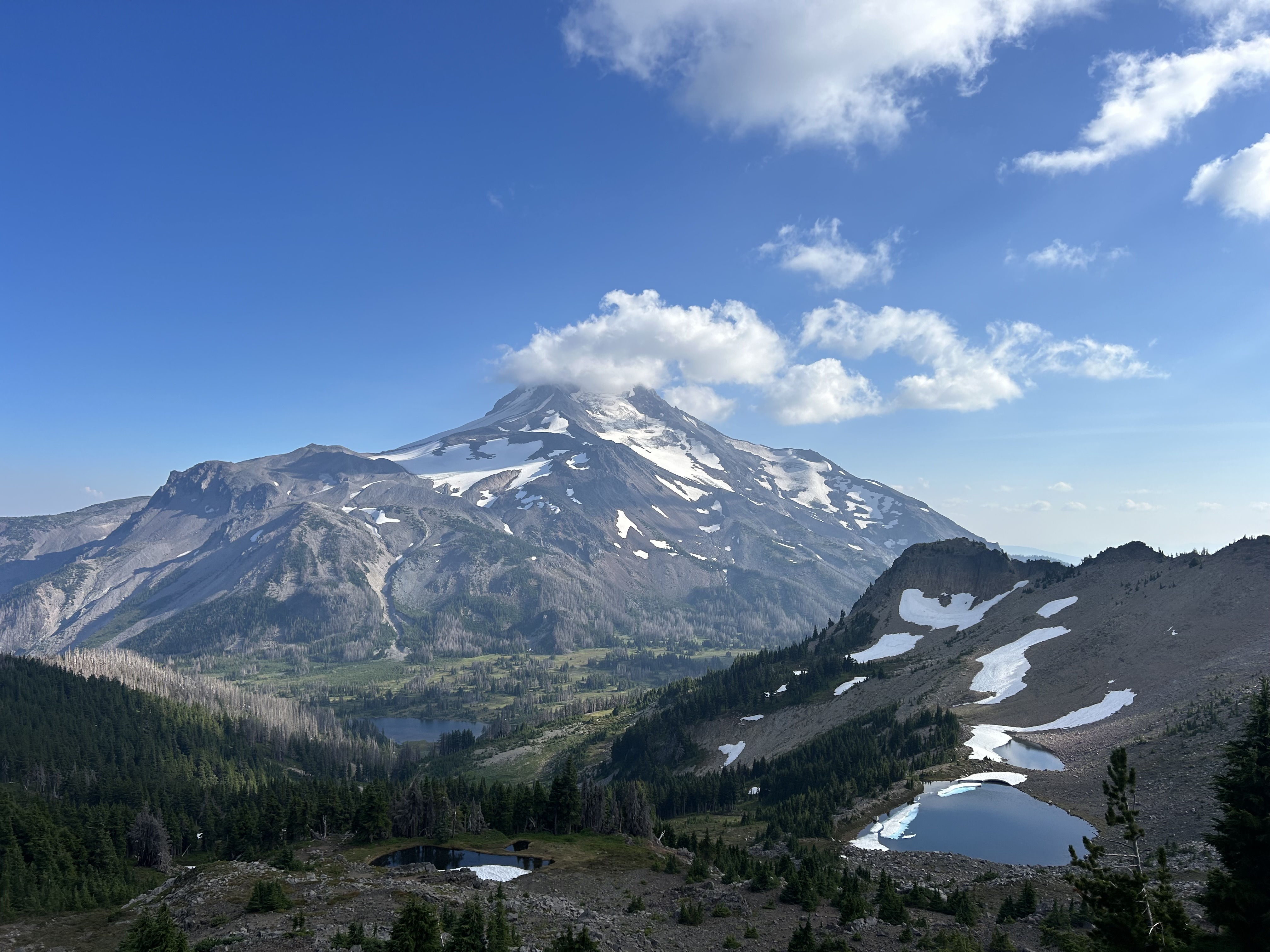
Day 110 was largely dominated by Mt Jefferson from multiple angles. A steep descent was followed by an equally steep ascent - luckily the views of Mt Jefferson made up for the pointless up and down. At about 8:30pm, I finally reached Ollalie Lake and was reunited with Sprouts and PowerPuff. Unfortunately, given my late arrival, all the campsites were taken and my bed for the night was cowboy camping on top of a picnic table.
 |
| Mt Jefferson (from multiple angles) |
 |
| Some of the delay-inducing blueberries |
 |
| Arrival at Ollalie Lake. Sprouts and PowerPuff waiting on the dock with Mt Jefferson in the background. |
Sprouts’ boyfriend flew into Portland from Canada and met us the following morning and drove us to Bend for our first zero day since South Lake Tahoe (almost a thousand miles ago!). The rest of Day 111 was spent at Trader Joe’s and preparing our food for the next section of trail. At our AirBnB, I also have my own room and bed (a luxury that I have forgone since Big Bear Lake - mile 226 of the PCT).
Days 112 and 113 were spent relaxing and enjoying Bend, the highlight being floating down the Deschutes River in tubes with the crew. Bend (with a population of about 100,000 is the largest town we’ve been in on trail) is awesome and I’m so happy with the time spent here. We also caught up with Jordan and Conner (the couple that I was hiking with in the Desert Section and haven’t seen since Mt Whitney) who live in Bend.
 |
| River Float Crew |
 |
| River Floating |
 |
| Sorting out the resupply in the AirBnB lounge |
We’re set to head back to trail tomorrow morning and intend reaching the Oregon/Washington border in a few days. Sadly, the fire situation in Washington is dire. Many people are ending their hikes at the Oregon/Washington border as the logistics further north are proving too difficult. It is likely that large sections of the trail will need to be skipped (which is really upsetting given how close we are to Canada and the relatively minimal interruption that they’ve had on our hike to date). Again, the situation changes all the time and decisions will be made as we get closer.