A sadly familiar sound awoke me on Day 127: rain once again on the outside of my tent. To make matters worse, my water bottle had broken during the night and my tent was equally wet inside and out. Washington certainly makes us work for her love.
The knowledge that town food awaited us at Snoqualamie Pass later that day was great motivation to crush the 20 or so miles needed. The views hiking down to Snoqualamie (a small ski resort) were great (despite the seven lane I-90 highway breaking the ambiance somewhat).
 |
| The view on the descent into Snoqualamie Pass |
 |
| Signs for Seattle. I guess we are getting close! |
 |
| Some trip planning on napkins |
After what was perhaps one of the best pizzas on trail, we went to DruBrew Brewery for a catch up with some other hikers and to plan the next few days.
Being back in civilisation also allowed me to get an update on the upcoming fire situation. To my relief, three out of the four fire closures had been lifted in the past week meaning there was only one closed section to navigate around. I guess the cold, wet weather did bring benefits after all.
There were four options to deal with the remaining closure:
1) Skip up ahead to Harts Pass and complete the remaining 35 miles from Harts Pass to the border (Sprouts and Powerpuff had chosen this option given that they needed to complete the trail by 1 September);
2) Take Detour 1 around the fire to the west which then connected just north of Harts Pass (this detour would pass several towns meaning a heavy food carry wasn’t necessary but involved more than 70 miles of highway walking which did not sound pleasant at all);
3) Take Detour 2 around the fire using a mixture of forestry service roads and other trails (this option was feasible and safe but was not going to be scenic); or
4) Take Detour 3 which involved continuing north on the PCT until its closure, dropping down on other disused trails through Glacier Peak Wilderness before rejoining the PCT at the north end of its closure at Suiattle Pass.
Detour 3 came with a caveat. No one had completed the route this season so there were no trip reports from this year. The detour also involved the fording of two rivers (which were impassable other than for a six week season each year), a traverse of a glacier, a climb of a scree-filled avalanche chute, and travelling on trails that were generally unused, overgrown and hadn’t been maintained in several years.
I figured that hopefully someone would have attempted this route and posted online about their experience before I had to make a solid decision about whether to take it or not when I reached the next town stop.
Back in town, despite numerous accommodation options available in town at Snoqualamie, we decided that we would hit the trail again and hike another five miles (all uphill - we are in Washington after all) that evening to camp.
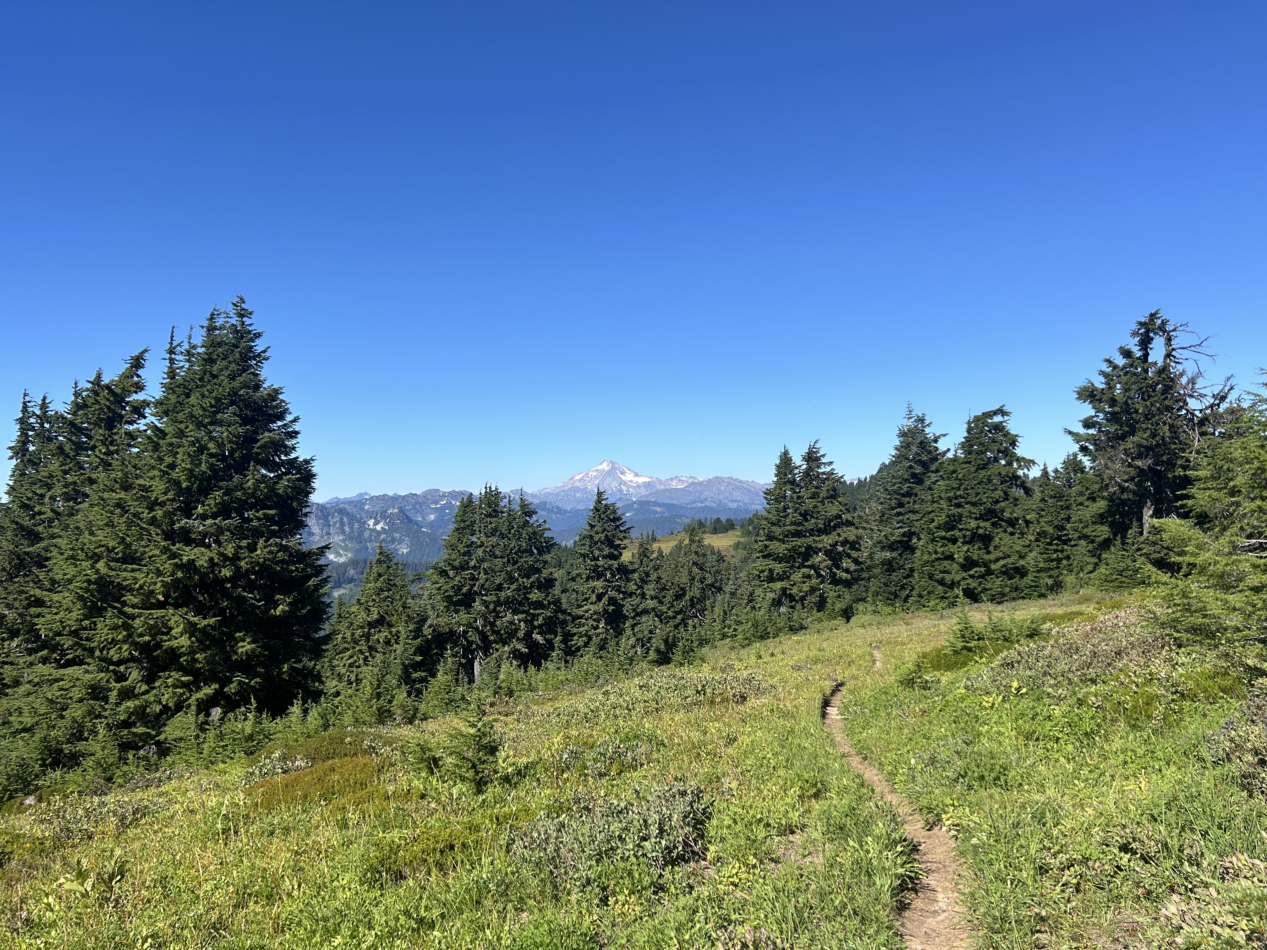
After a bit of a sleep in we started hiking shortly after 7:30am on the morning of Day 128. Mile for mile, Day 128 was probably the most scenic day on the entire trail. The views rivalling anything we had seen to date (including portions of the High Sierra). Multiple times during the day, you would turn a corner and your jaw would literally drop at the views. For the sake of brevity (which I acknowledge I’m failing with) I’ve limited myself to ten photos below from the day:
 |
| Tahoma in the background |
 |
| Pretty chuffed |
 |
| Not a bad spot to camp for the night |
The epic scenery continued well into Day 129. The views of the granite mountains on the descents reminded me a lot of those in Yosemite. Despite the cold water temperature, a dip in the creatively-named Deep Lake was one of the highlights from the day.
 |
| Quick dip in Deep Lake |
 |
| Deep Lake from above |
 |
| Sunset views and heart-shaped lakes |
Day 130 involved a 15 mile hike to Stevens Pass. After about 35 minutes, we managed to score a hitch halfway to Leavenworth (the final town stop on trail). Then about five minutes of waiting outside a diner, we sorted another hitch to take us to Leavenworth. Our hitch was very excited to pick up us and gave us fruit pies for the journey.
 |
| Stevens Pass - another ski area |
 |
| Pies in the ride to Leavenworth |
 |
| Leavenworth - I |
 |
| Leavenworth - II |
Leavenworth is a strange little town. It is ostensibly modelled on a Bavarian village and all shops and buildings in the town centre follow this theme. Despite best intentions, it does seem to fall a bit short of the mark; I’m not sure how many Bavarian villages have a major highway running through the centre, are filled with parking lots with Chevy Escalades, and charge $23USD for a beer and a pretzel (scheiße!).
Despite this, I really enjoyed my stay and had a great farewell dinner with fellow hikers (including Sprouts and Powerpuff with whom by this stage I had hiked with for more than 2,100 miles and 800 miles, respectively).
After dinner I checked online to see whether there had been any trip reports on the rugged Detour 3 option. Unfortunately, no one had completed it yet (and lived to tell the tale). However, I decided that after four months in the wilderness I had sufficient experience (right?). Also, someone had to be the first one to complete it this season - why shouldn’t that person be me? Given that I would be hiking alone, Powerpuff let me borrow her satellite messenger to send check ins and I provided my intended route with friends. I was intentionally vague when telling my parents my plan given that I knew that I would have received a resounding “no” from them if they found out my route.
The morning of Day 131 involved my last hotel breakfast, a very sad farewell to my hiking buddies, and my final hitch back to Stevens Pass (with a seven day food carry) for my final stretch before Canada.
 |
| Powerpuff and Sprouts: a very sad farewell |
I had heard that hitching from Leavenworth back to Stevens Pass could be one of the more difficult hitches on trail so before leaving I spent some time making a sign using my tent groundsheet reading: “PCT Hiker - Stevens Pass” in bold Sharpie hoping that it would aid my plight for a ride. My artistic endeavour was (sadly) in vain because as soon as I left the hotel, a father and son who were driving past pulled over and asked if I needed a lift to Stevens Pass - incredible! The driver was pretty knowledgeable about the area so I quizzed him on my intended route for the detour.
The remainder of the day saw me hiking 25 miles and included what would be my final swim on trail.
 |
| The last lake I would swim in on trail |
Day 132 included nine more miles on the PCT and then beginning the start of the detour through Glacier Peak Wilderness. Glacier Peak Wilderness is known to be one of the most rugged and remote areas of Washington and together with the North Cascades National Park one of the only areas in Washington where grizzly bears are found (!). Grizzly bears are being actively reintroduced into the area as they are a threatened species.
The start of the detour, while rugged and certainly less well-maintained compared to the PCT, was completely manageable and visually stunning. I quickly became glad that I had opted for this option. The ruggedness also meant that my pace was considerably slower.
 |
| Final little section on the PCT before the detour begins |
 |
| Start of the detour. The trail was overgrown and was actually straight in front of me in this photo |
At about 7:30pm, I called it a night at the top of Boulder Pass.
 |
| I didn’t realise on the approach that I would be summiting this |
 |
| Boulder Pass - camp for the night (excuse the terrible tent pitch) |
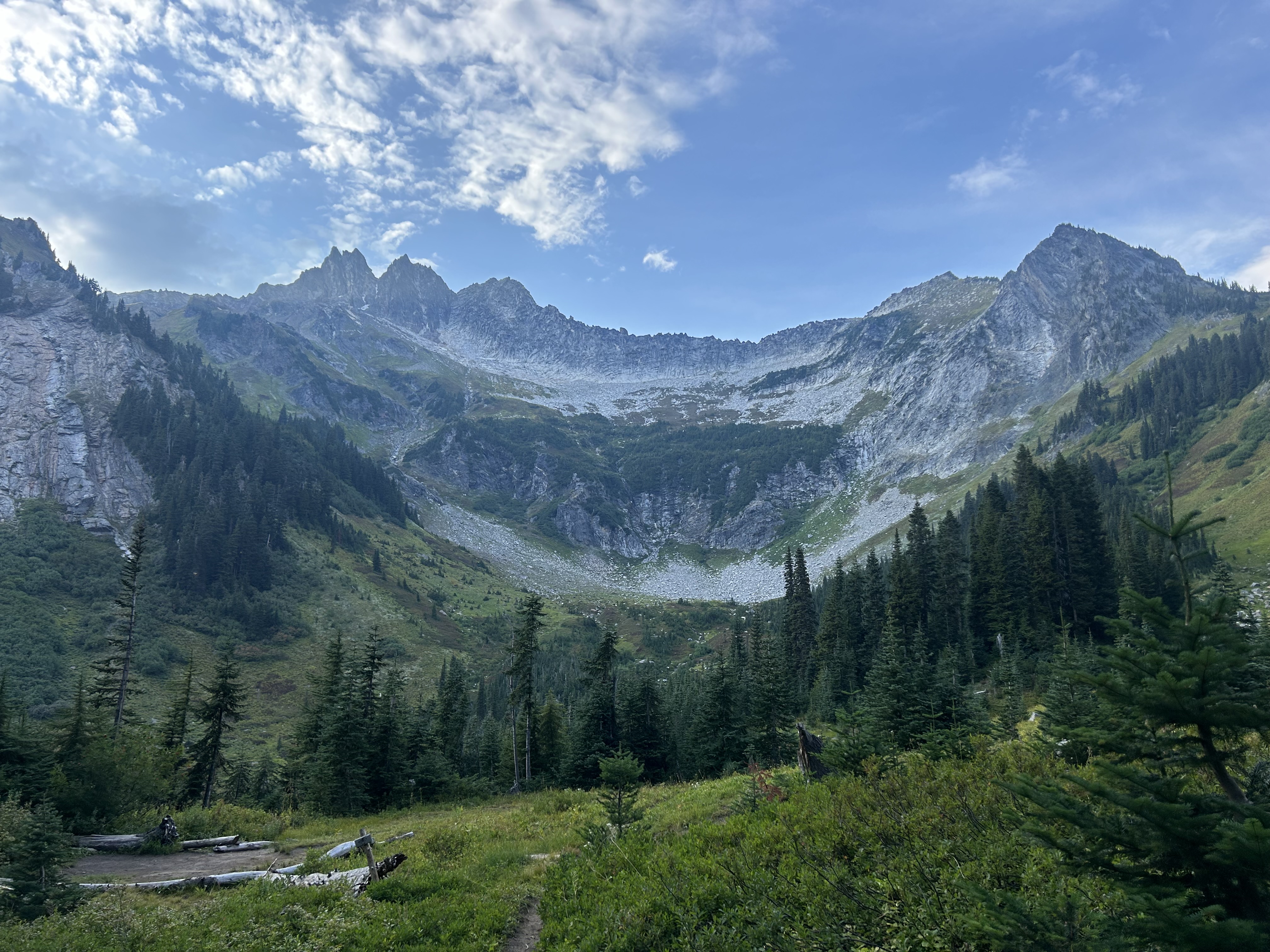
The following morning involved the descent down into the Napeequa Valley, shortly followed by the ascent up Little Giant Pass. I’m not sure why the word “little” was included, this pass was pretty tough going and pretty steep - rivalling any of the ascents on trail to date (as evidenced by my perspiration-soaked shirt).
The view from the summit was one of my highlights from the trail for sure.
 |
| Sunrise views |
 |
| Napeequa Valley |
 |
| View of Napeequa Valley from Little Giant Pass. Boulder Pass (with the glacier) on the left is where I had camped the previous night |
 |
| Insane views |
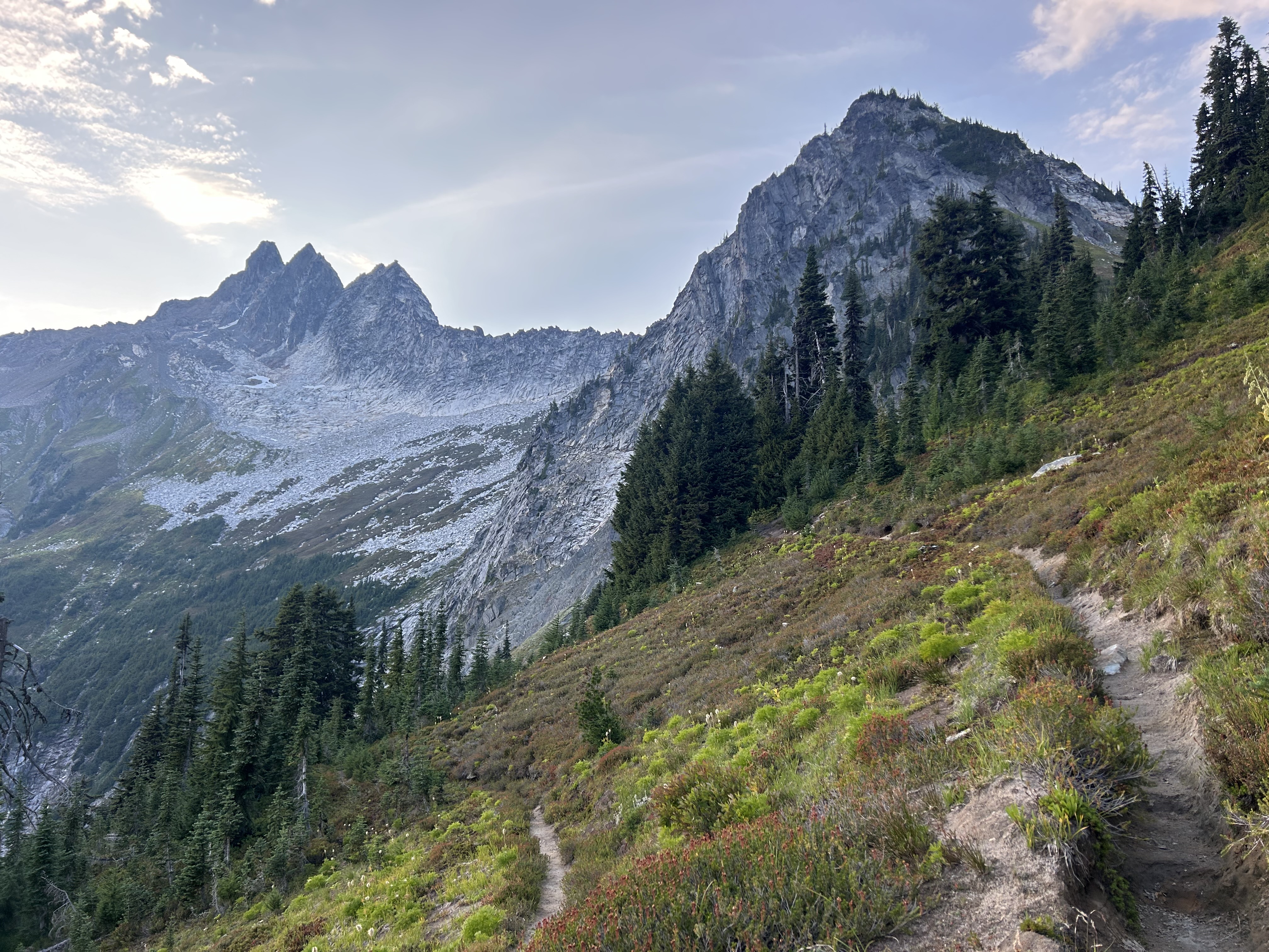
After descending Little Giant Pass and a brief lunch stop, it was off to Spider Meadows for the next pass of the day. After reaching Spider Meadows, it was a bit of a sketchy traverse over ice and the avalanche chute of scree - luckily I made it to camp unscathed.
 |
| Spider Meadows |
 |
| On the ascent |
 |
| A small snowfield to cross - the clouds rolling over the mountains were beautiful |
 |
| Upper Lyman Lake |
 |
| View from camp |
 |
| Again not my best pitch |
The following morning involved crossing Cloudy Pass and then Suiattle Pass - the latter rejoined the PCT.
 |
| The clouds over Cloudy Pass |
 |
| Finally back on the PCT |
The rest of day was spent hiking downhill for another 30 or so miles before the trail entered the seventh (and final) National Park: North Cascades National Park.
 |
| The trail was a bit overgrown at times - it all adds to the fun, I guess |
 |
| Crossing into the final National Park on the PCT |
 |
| Looks cold! |
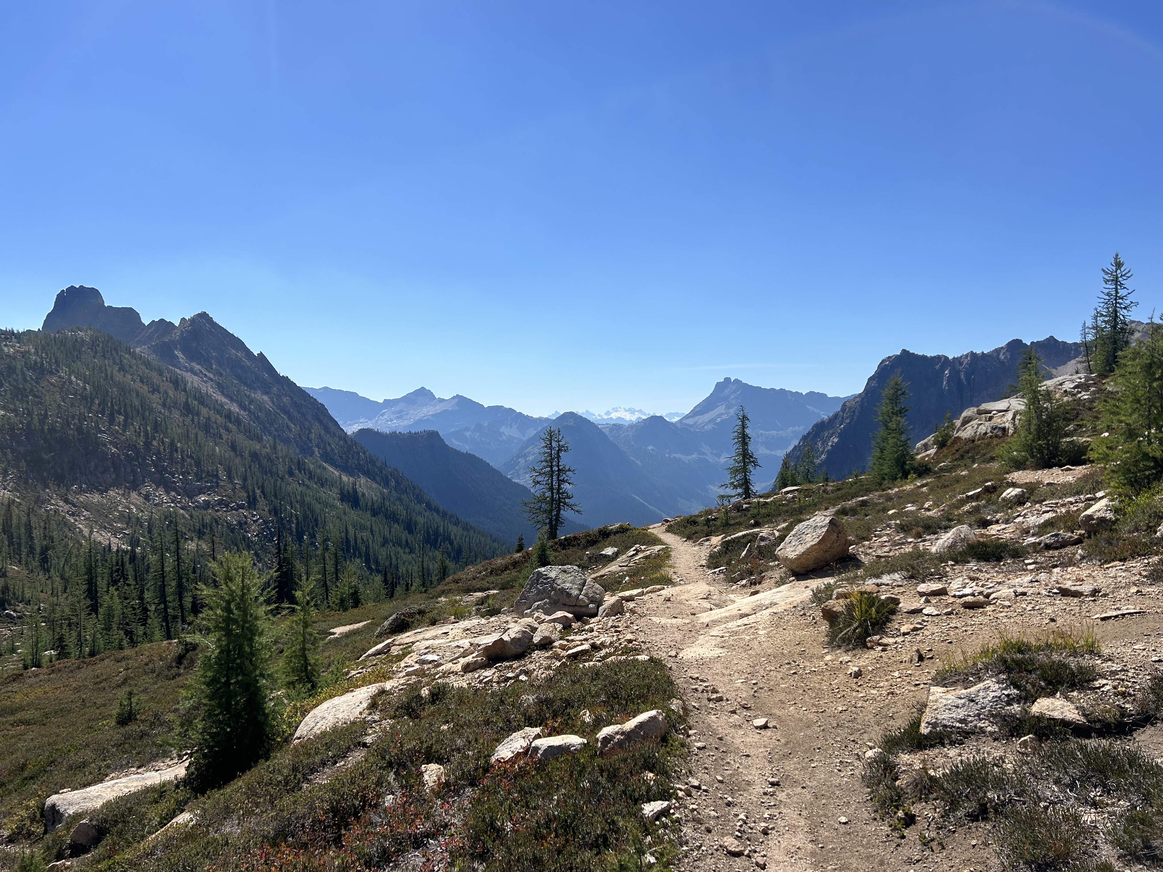
Day 135 involved hiking about nine more miles through North Cascades National Park before crossing the Washington Scenic Highway to Rainy Pass. It was quite funny, almost as soon as I left the National Park boundary, the scenery was exponentially better (I’ve come to learn that the National Parks are not necessarily the most scenic parts of the trail by far!).
 |
| Rainy Pass |
The scenery by Rainy Pass was exquisite! It reminded me a bit of the Desert section at the beginning of the trail combined with the greenness of Washington.
Day 136 marked my last full day on trail before reaching Canada. The day was equal parts excitement at the idea of reaching the border and sadness that this journey was ending.
After hiking past Harts Pass, a sadly familiar smell reappeared: smoke. News travels quickly on trail and I learned that a new fire had broken out close to Harts Pass. Luckily, it was to the south and was several valleys away. However, as the day progressed the smoke became more apparent.
Only about half the people hiking the PCT decide to enter Canada, the others tag the monument at the Northern Terminus, hike back to Harts Pass and hitch from there. Given this, you encounter many people completing their ‘victory lap’. It’s exciting congratulating people who have finished and likewise them congratulating you on almost finishing.
As the sun began to set I stopped for about 45 minutes just before the final pass of the trail and just took it all in reflecting on the journey that has been.
 |
| This was the point where I stopped for about 45 minutes |
 |
| After this pass, it was all downhill to Canada |
 |
| Final sunset on trail |
Waking up on Day 137 (which happened to be my 31st birthday) was strange. I only had about six miles before reaching Canada and was in no rush to complete those miles.
 |
| Final morning before Canada |
I had arranged to meet up with Matt (with whom I had been hiking with from mile 300 to about mile 1500) and hadn’t seen since Mt Shasta in Northern California) so that we both wouldn’t be finishing alone. Without cellphone service in this section, Matt passed messages onto me via hikers walking in the opposite directions as to where he would be waiting for me.
After about an hour of hiking, Matt and I reunited and hiked the final three miles together - the analogue method of communicating was successful after all. Reaching the Northern Terminus was somewhat strange. There is a monument marking the end of the trail in the middle of the forest (which in turn is in the middle of nowhere), a clearing of the trees demarcating the United States from Canada, and a ‘Welcome to Canada’ sign. I had seen photos and videos of this before, but it felt surreal reaching it in person.
Matt and I took the obligatory photos, had the celebratory beer, signed the register, and finally just sat below the monument reflecting on the journey that was over the past four and a half months. After about an hour and a half, we decided that it was time to move on and hiked the remaining eight and half miles to Manning Park, British Columbia, Canada.
The ‘border crossing’ was unmanned and nothing more than a clearing of the pine trees - a stark difference from the fortified and obscenely high border wall at the US/Mexico Southern Terminus.
 |
| Matt and I |
There was a hotel at Manning Park where Matt and I stayed and had a celebratory dinner. Matt had loudly wished me Happy Birthday in front of our waitress which meant a free round of drinks. The following morning, friends from Wellington who had moved to Vancouver earlier this year (Liam and Sara) hired a car to pick Matt and I up and shuttle us back to Vancouver and back to proper civilisation.
 |
| Dinner at Nightingale in Vancouver - highly recommend! |
 |
| Cycling through Stanley Park, Vancouver |
I also took the opportunity to jump on the scale at Liam and Sara’s: 77.5kg - I can’t remember the last time the scale started with a 7. Who would have thought that hiking more than 20 miles per day for almost five months produced a calorie deficit?!
It was funny just how quickly you can become accustomed to being back in the city: the noise, the people, the energy.
Despite reaching Canada, my journey on the PCT wasn’t finished quite yet. You may recall that in Northern California I was forced to break my ‘continuous footpath’ due to the Shelly Fire where there wasn’t a viable alternate or detour available. These 26.9 missed miles had been occupying my mind ever since and I wasn’t ready to head back until these could be completed. Luckily, two weeks prior to finishing, this previously-closed section of the trail had reopened.
So, on the morning of 10 September, I caught a bus from Vancouver, BC down to Seattle. In Seattle, I hired a car and made the 10 hour journey south to the town of Etna in Northern California (given public transport limitations in rural California, hiring a car was, in reality, the only feasible option to reach the remote trailhead).
On the morning of 11 September, I drove to the trailhead at Etna Summit, left the rental car parked on some abandoned gravel road (the rental car company would love me for this), and once again hit the PCT. The morning was rainy and cold (a far cry from the almost 40° C weather six weeks back) with no visibility of any of my surroundings. Along I trudged for the whole day and just after 7pm, with gloveless hands so cold from being exposed all day (my fingers are still numb writing this a week later), I reached the Box Camp trailhead junction on the PCT and officially completed my continuous footpath of every single step from Mexico to Canada.
 |
| A both significant and completely insignificant part of the trail. Forcing a smile (sort of) in spite of the cold |
 |
| Box Camp Trailhead |
I set up camp for the night ready to make the journey back to the trailhead (and hopefully my non-damaged rental car) the following day.
The following morning the clouds had disappeared and the sun was bright in the sky - a fitting farewell to the PCT. I took my time, I was in no rush; forcing myself to slow down so as to prolong officially bringing this adventure to a close.
 |
| Marble Mountain Wilderness |
 |
| It was beautiful when the the clouds and rain finally disappeared |
Over the next few days, I drove down from Northern California, down Highway 1 past San Fransisco, Big Sur, San Simeon, Los Angeles, and finally down to San Diego where five months earlier my journey had begun. It was funny, driving down the highway I saw exits for the places that weeks or months ago I was hiking through: Chester, Crater Lake, Lassen Volcanic National Park, Tehachapi. How funny, all those months on trail step by step, with such beauty existing parallel to an interstate highway.
 |
| Big Sur |
 |
| Hearst Castle |
 |
| Fresh fruit (perhaps not the best choice of lunch while driving down Interstate 5 in LA traffic) |
 |
| Belated birthday celebrations with family in San Diego |
So, what can I say about the best summer of my life that I haven’t already said before? Perhaps, it’s mostly that I’m grateful. I’m grateful that I’ve been able to experience some of the most exquisite natural beauty that I’m sure exists in this world. I’m grateful for the friendships that I’ve formed. I’m grateful for my health and I’m grateful for my body (ha! I didn’t think I would be saying that!). Above all, I’m grateful for the genuine kindness shown by people: by friends, by family, and mostly by strangers who helped me along the way.
Tomorrow at midday I’m flying out of San Diego for a bit of travel (I need a holiday from my holiday, you know?) before getting back to New Zealand in mid-October.
Thank you to everyone who has been reading this and who has been sending me messages of support along the way. I apologise for the terrible formatting, spelling, grammar (and, at times, content) of some of these posts. It’s been so much fun sharing my journey with you all. Perhaps, I’ll revive this blog when I do the Continental Divide Trail (the PCT’s longer, harder, and more rugged sibling trail from Mexico to Canada) next year…I jest (maybe).
Until then, Banana Bread out 🤙🏼
Pacific Crest Trail
23 April 2024 - 6 September 2024
“Suddenly, I came out of my thoughts to notice everything around me again - the catkins on the willows, the lapping of the water, the leafy patterns of the shadows across the path. And then myself, walking with the alignment that only comes after miles, the loose diagonal rhythm of arms swinging in synchronisation with legs in a body that felt long and stretched out, almost as sinuous as a snake. When you give yourself to places, they give you yourself back; the more one comes to know them, the more one seeds them with the invisible crop of memories and associations that will be waiting for you when you come back, while new places offer up new thoughts, new possibilities. Exploring the world is one of the best ways of exploring the mind, and walking travels both terrains.” - Rebecca Solnit, Wanderlust: A History of Walking